Passing through Aratula, we take note of the usual tourists stopping off to grab some cakes and coffee or take advantage of the fruit store in the centre of town. On the outskirts we see blokes in 4wd’s pulling up outside the pub and think it is a bit early for it. Perhaps they are planning to grab some seafood at the mobile fisho
who operates from the carpark.
who operates from the carpark.
Spicers Peak ...

It's only UP UP UP from here.

Parking up the ute at the most likely spot to pitch camp, we take a walk around to survey the surroundings. Noting the usual drop toilet building, we approach to see how many we’ll have and whether the view from the throne is worthy of the World Heritage Listing the park has. There are only 2 … one male … one female … and the view isn’t worthy at all.
Bollard Anyone?


Two vehicles have pulled in behind our parked ute, and the grey nomads contained, start to set up for morning tea … which upsets Glenn a little. This whole are to occupy, including a purpose built picnic area … and they park beside us. Crazy really, but that’s what people do I guess. Some can’t bear to be apart from everyone else.
So, rather than set up the campsite, we head to view the Pioneer Graves, which is a 130 meter walk from the picnic ground car park, which is about 250 meters from where we’ve parked in the camp ground. There aren’t any actually “graves” as such, because back in 1936, the graves themselves were rather run down and a local thought a cairn would be nice to mark the site. There are believed to be 13 people buried in this area, including Mrs Collins, a bullock drovers wife, and her child, who both fell from the dray on a steep bit.


Once they have moved vehicles up to the picnic area, we spin things around and start to set up. Before we have the whole kit and kaboodle up set up to simply sit and relax, I suggest we head for the lookout … which will save us having to put certain things out only to have to put them away again. Governers Chair lookout is only 2k from the campground and has a superlative view of the surrounding countryside slightly east and north of our location. You can clearly see ski boats on Lake Moogerah as well as some fires off in the distance. The lookout is so named because Queenslands first Governer wished to see the view after being told so much about it, and then made it his favourite place to visit. Back then, you didn’t see farmland, towns, cities, any dams or lights. I can imagine it was a rugged landscape, filled with trees and birdlife.


Half way back down, we stop in to view Moss Well, so named for Mr Moss, the original road builder commissioned on this track. He sunk a well on a natural spring, which assisted the pioneers and their stock for many, many years, but is now overgrown and almost filled again, but it still does flow. NPWS don’t recommend that you drink the water, but it’s kept many a pioneer from the brink of death in the past. There is even a poem gracing the sign which I was inspired by.


Back at camp, we complete the setup and start to relax. I check out the other sites one by one, wander through the bush a little, read the signs at the campground entrance and near the picnic area, learning much about where we are camped, especially it’s history.
It does seem weird to have a Mango plantation across the road though and makes me wonder how much it will get plundered once they ripen, regardless of the Private Property sign.
We get heaps of bird visitors to our camp, proving that people are feeding them. Currawong, Kookaburra and Shrike so far, being the main food begging culprits. I can hear finches, bellbirds, curlews, just to name a few.


No Optus reception ... even up that high! Wanna borrow mine?

We see a few bandicoots scurrying around the camp during the night, and they are quick little furry creatures too. I can’t get a photo of one as they disappear at the smallest sound, and apparently raising the camera from your lap warrants as a small sound.
Just before 1900, we head back up to the lookout. It’s River Fire night in Brisbane and we are interested in what we will be able to see. I will mention that it will have to be much brighter and much taller to be seen well from here. We can see short spots of colour (mostly red) and that’s about all really. Pity the F1-11’s aren’t doing their thing anymore, as they would have been great to see from up here. Disappointed, we head back down to the cold, dark campsite.
Bird calls abound, so we will sleep peacefully.
Next morning I’m awoken at 0800 by a car circling the lot. It’s the first of many Sunday drivers and bike riders out for a bit of serenity. So bacon, eggs and coffee are called for I reckon. The friendly birds are on the ball this morning, asking for some bacon and eggs as well.
Weird Bug we spotted.

The day starts out perfectly blue skied, but that changes to almost totally overcast as it progresses along towards lunchtime. The sun is wonderfully warm, but the clouds make it rather chilly as the wind has picked up a bit as well.
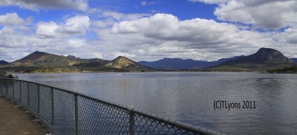
As usual we do the slow pack up, stopping often for a sun break, but by lunchtime we are packed away with nice dry canvas and wondering what to do now. Do we drive the hour home or go via the scenic route? Scenic Route it is. Once back down on the bitumen, at the corner of Spicers Gap Road, left goes to the highway and Aratula, but right goes on a slow loop around Lake Moogerah. We head right and plan to stop at the dam wall for a look.
The road is mostly gravel from here to the next intersection, and we find the Elephant Rock nudie camp entrance along the way. As we skirt the lake I think it amazing to see so much water. Last time I was here it was 3%, but looks like it’s currently at least 90%.
We keep turning towards Kalbar on the signs, and finally find a sign that heads us to the dam wall. You can walk right over this one as long as it’s between either 0600 or 0700 – 1700 or 1800 … signs can’t make seem up their minds. But it’s a very short walk regardless of what time you are able to do it.

At the far side, you can then do the 3k hike to the top of Mount Edwards if you like, or you can return to the picnic area and make good use of the facilities, as long as you can handle the background noise of ski boats passing back and forth and kiddies playing on swings. We had a good wander around and decided it’s time to head for home. We’ll even make it home early!
Trip Kilometres: 293
Trip Duration: 48 hours
No comments:
Post a Comment