Our destination reportedly a 4x4 must do in northern
So we plan to stay along the
We are also trialling our new Dog Box. Glenn has designed it to fit on the ute with the sides up. It’s been made up by professionals, and Glenn has modified it a little to keep them cool by using a coolite slab coated with concrete (used in walk in freezer walls) up on the roof. It’s a thing to behold and very flash for the pups. He’s put in a temporary floor as well and we’ve thrown their beds (puppy pillows) in there to give them some comfort and foot holds. Today is it’s first outing and I’m keen to see how they like it.

As we head down the Mount Lindsay Highway Mount Lindsay Highway


 We then cross the border and stop at Woodenbong to see if the local servo (a Royal Auto Club office) has a more detailed map.
 Alas.

Mount Lindsay


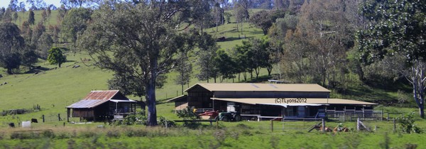
Back in the car, we head left before the servo and drive another 13k’s to Urbenville. We stop here to check out the

I saw this funny sign ...

From here, we head south east and wing it. Map says it’s about 12k or so. I keep an eye out for a sign post, but spot one of the 4x4parks signage first. Once on the road, get Glenn to check the trip meter and we head south.
The first part of PFR is rather pretty. It’s paved and we enter valley after valley of agricultural land, pass fat cows eating or resting in the shade of trees. The scenery has been marvellous and continues to be so until we head up into the hills more. Heading up is really not quite what we are doing … rather driving up one of the steepest sections in this part of the country – for what seems like miles. Up, up and still continuing up for some 20 or so k’s. The trees have closed in on us, so there is no view to speak of and the road has become a one lane affair, so we are concerned that oncoming traffic are doing it slowly, but we see no-one at all. Parts of the road are barricaded off due to some rather difficult weather in recent times, so the going is slow. Glenn is not having too much fun as he’s intent on the road and what may be coming around the next hair pin bend.

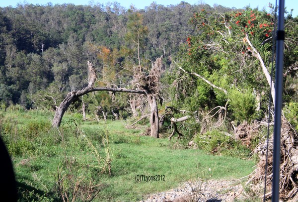
We continue on an upward spiral until we get to the driveway for Clarence River Valley Wilderness Lodge. Here it starts to plateau off for a bit, still climbing but not as steeply anymore. Once past their drive, we start to notice the track becoming more overgrown with lantana … the pin striping nemesis of many a 4wd. Eventually we start to head down.
So far we are at more than our 3 hour limit from home. Once we arrive at the river crossing we note that it’s been 3.5 hours in the car and we have to let the dogs out for another drink and stretch. They do seem to be enjoying the new box well enough though so that’s a good thing. We spend about 15 minutes getting them watered and some trees watered and then pack us all back up to search for this elusive camping area. We cross over the river and see two blokes metal detecting along the shore line, so this is a great opportunity to ask questions. They say they are from Clarence River Wilderness and are waiting for canoeists coming down the river. Yes we are at Paddys Flat and yes we can camp here, although they both recommend heading back to their property. Alas, we have dogs, so that’s a no go. We are just lucky that it isn’t a long weekend as there are usually limited spaces available by now. Agreed. We chat about things for a few minutes and discover that the bridge was under water last week.

So we turn the rig around and head back to where we were. The nice fella’s have said if we head further up the river there is a nice spot, so we do. And it’s a cracker. Beach and all. However the river is flowing at a great rate of knots so don’t think we’ll let the dogs wander out too far … might never see them again.


Set up now runs smoothly and we are in the shade in under ½ an hour with drinks in hand. Dogs are sniffing around or rolling on the excellent grass under foot. And we relax. Looking around the area, I see debris high in trees that would be well under water during a flood.
Once over the bridge we find the canoe’s being loaded onto the Landcruiser and people with happy smiley faces. This will be the owner’s second trip down here to our knowledge, and it’s a nice spot to be. I wonder how many more he will make before the day is through.
We head further downstream and I notice some tank traps. I’m not sure of the history of these, but I’m keen to find out. As the pups head into the water, so do we. It’s very refreshing and I don’t want to get out, but I’m getting thirsty.

Back at camp, we do some more sitting, some more drinking, some more splashing of water over both us and the pups. I love relaxing away from suburbia. It’s the best.
We note that a lot of planes are flying over. Each one leaves a trail behind it, so we know that they are going in the same direction. Brisbane to Sydney
A motorcycle heads directly past our camp (about 2 metres away) and neither the dogs nor us even hear him coming. Luckily we are not doing a Nudie Camp which had crossed our minds though.
Time to think about dinner I guess. Lamb roast with veg. Glenn sets up the OzPig while I organise the vegies. We start the fire and get things on to cook. We don’t care how long it takes. We are eating by night fall and then the bugs descend. It’s just bug heaven and we retreat to the camper quicker than you can say “Man there are heaps of bugs here and one just bit me!”. Looks like the rest of the evening will be held indoors. And we are off to bed early. Not too bad as the sound of the river works it’s magic on our souls.
19.02.12
Our day starts early due to the early night. It’s very misty out there, so we relax in bed for awhile until the pups get too restless, which doesn’t take long once they realise we are awake.Breakfast is a toasty affair where I learn not to keep your tea bags with your herbs and spices … your tea becomes very herby and spicey.
We head down to the creek for a refreshing dip and wait for the mist to burn off which it does quickly. The sun beats down and we find it’s to be much warmer than yesterday.
Glenn notes that the water has gone down a bit since we arrived. More planes go overhead, no cars go past either.
I seem to have gotten burnt shoulders yesterday and take some time to coat myself in sunscreen and do some more relaxing. Around 1100 we’ve packed a few things away and are sitting to let the sweat dry and notice more canoes going past. The landcrusier must be back down at the bridge waiting for them. We didn’t even hear it go past. We plan to be on the road by 1200, as we aren’t 100% sure on how much further PFR goes for before it hits the Bruxner Highway or how long it might take, so we start our pack up in earnest. 
We head up hills steeper than we did yesterday and Glenn once more curses the overheating auto in his Hilux. We discuss whether the bash plates may have anything to do with it but are unsure. Heat of the day, steep hills to climb, towing a heavy camper … who knows. Needs looking into though as there are hotter places than the Great South East! Next place to pass is Pretty Gully which isn’t a gully precisely as I’d know one, but I think it was rather pretty. It’s another 17k’s to the highway, bringing PFR to a total of 63k.
Then it’s a left at the highway and within moments we are crossing the Clarence River
Opened in 1903, it is the longest De Burgh timber truss bridge in NSW
and is of national significance. It crosses the Clarence River before you
enter Tabulum (home of the original Light Horse Brigade).


Back in Urbenville, we stop once more at the State Forest
Once again we are on the road back to Queensland
Coming back into Rathdowney, we note that the caravans in the show ground we saw on the way down are still there and appear to be relaxing their hitches off.
Looking back towards Mt Lindsay to spot another storm.

No rain in Beaudesert either. No rain in Jimboomba where we get a green light for a change. Looks like South McLean got the rain, lucky them, and the road is still wet till after the Logan River
After 4 hours on the road, we pull into the driveway, glad to be home and saying that we now know why people flock there on a long weekend.
Dog Box a complete success!
Trip Kilometres: 445Trip Duration: 48 hours
2 comments:
Well you have been to my patch! You may recall when you left Paddy's Flat to go into Tabulam you got to the highest point where the 'Pretty Gully' sign was just after the start of a kilometer or so of bitumen down through the scrub. The property on the left with the long row of jacarandas and down to a hundred meters or so from where you come out into the open country again is our spot of paradise! The tank traps in the Clarence River were part of the "Brisbane Line" from WWII. There is a lot of debate about if the Line was a reality and where it went. Well, the tank traps were originally in the river and hauld out at the end of the war. Also, about 10 meters before the second ramp (cattle grid) after you leave the river and about halfway to the top of the hill, you may have seen a few remaining posts in several close lines at right angles to the road and extending off into the trees. These formed the second line of defence if the tank traps in the river were breached. They are not mentioned in any writings I have read on the area and unfortunately the majority of the posts have fallen victim to termites and fire except for some of the iron bark ones. I doubt if many of the newer locals would know about them and as my brother and I are the two who have the longest association with the area (a bit scary) perhaps we should record what we know of 'recent' history from 1945.
Another great article!
Post a Comment